June 2012. Report by: Bryan Rynne
Present:
- Bryan Rynne
| Click on a photo to see a bigger version; click again for an even bigger version. |
 |
 |
 |
 |
 |
 |
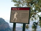
In June this year I found myself in Arizona at a conference on 'variational methods for nonlinear elliptic partial differential equations' (someone has to go to these conferences). You can imagine how much fun that was, but I did feel that there must be something even more exciting that I could do while I was there. Given the location, the obvious thing to do was to go up to the Grand Canyon and nip down to the Colorado river and back out again, the same day of course - I couldn't be bothered camping down there. Checking up on the logistics of this, in a multitude of guides, the uniform opinion seemed to be that this was out of the question and could not be done. The National Park authorities strongly reiterated this view on their web site. When I got there I also found that the canyon rim and the trails are festooned with signs saying: 'if you try to walk down and back up again in a day you will die horribly' (paraphrasing slightly here).
So, a slightly negative view of my plan, but I remained undaunted - this could not be correct, surely, despite the apparent unanimity. Reading the fine print and looking at the map (well, actually, a sketchy diagram of the sort that was traditionally scribbled on a fag packet to go walking in Scotland, in winter) it was clear that there was a route down and back up again that only involved 15 miles and 6000 feet of ascent. For a man who has done all the Munros, tops, furths, Corbetts and Donalds, and a fair amountof strolling around in the English flatlands, this seemed piffling. This multitude of warnings clearly could not apply to me - what could go wrong?
Well, possibly the fact that the south rim (the one I was intending to start and finish at) is at 7000 feet, and temperatures in the canyon reach 120 degrees Fahrenheit (all units in this report are imperialist, since I was in America, and in particular all the thermometers I looked at were in Fahrenheit). This did seem likely to be an inconvenience to someone used to the Scottish summer (and of course is the reason that people die doing it). However, I had a sunhat and some factor 30 suncream with me, so surely that ought to dispose of that problem.
What else was there to worry about? Well, perhaps the 'steep and difficult trails' that the guides also kept mentioning - these guys could do with a bit more positive thinking and looking on the bright side of life. To deal with this problem I resolved to stop reading any more guides and just get on with it.
Having done it, and survived (obviously), the message to anyone contemplating doing it is this: it is nowhere near as hard as the guides make out, but you have to use some common sense (I may be an idiot, but I am not a complete idiot). Here is some practical information based on my walk.
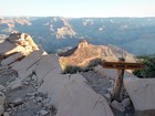
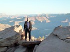
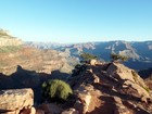
Start at dawn - I mean that literally. Anyone who knows how much I like early starts will be amazed to learn that I started walking down at 5.30am. The main advantage of this was that the temperature was 40 degrees (for the benefit of younger European readers, that is fairly cold, despite what it sounds like). It is also a stunningly spectacular time of day, with the sunlight slanting along the canyon picking out all the topography that disappears in the pollution haze when the sun is high in the sky.
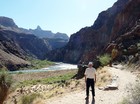
I walked down the South Kaibab trail, which is 'steep and difficult' according to some guides but is easy angled and trivial to anyone with normal walking abilities - it's about as steep and difficult as the Mound. I did the whole trip in 'innovate' fell running shoes - don't wear boots, you don't need them and your feet will be hot! This trail goes down a ridge, so you get fantastic views along the canyon, both ahead of you and to either side. The only disadvantage is that there is no water available on this trail. Since I got to the bottom by 9.00 and was walking back up again by 9.30, in temperatures of about 80-90 degrees, this was not a problem. I also carried 4 litres of 'powerade' salt and sugar drink. This smelt like urine (I can't say whether it tasted like it), but it did a very good job of keeping me going - all the guides say you need plenty of salt and I took them seriously on this. I also had some muesli type snack bars - I felt that my usual walking fare of snickers bars (which some doctors feel provide a fully balanced range of nutrients, including essential vitamins and minerals, for a hard day out) would have melted by the time I came to eat (or drink) them.
I went up by the Bright Angel trail. This is longer, but easier angled, than the South Kaibab, but just as well made. It also has 3 water taps along the way, a few miles apart - so you can refill your powerade bottles and basically drink as much as you like on the way up. In fact, in total I only got through 3 litres of the powerade and 1 litre of water straight from the second tap. There are also several 'rest rooms' along this trail - no, not toilets, although this seems to be the current American euphemism for 'toilets' (which is also, of course, itself a euphemism, so it hardly seems in need of a euphemism), but covered areas with seating and shade so you can have a rest out of the sun. The ascent felt a bit of a slog mid-way, in the heat - over 100 degrees by then, and rising. However, by taking it slowly and plodding along I got there without too much bother. I 'summitted' at 1.30, so most of the ascent was hot but not in the worst of the heat.
Slightly surprisingly, I did the walk in just about bang on Naismith time. Since Naismith had in mind walking in Scotland, i.e., in cold, grey, rainy conditions when you don't bother stopping to take photos, I was a bit surprised to manage it so quickly. On the other hand I encountered no blanket bog, deep heather or steep scree slopes, just well made tracks, so that may explain the pace.
As mentioned above, I did this in lightweight 'innovate' fell-running shoes (walshes would have been more hair-shirt than necessary for walking on well-made trails) and, apart from the first half hour, I just wore a T-shirt, lightweight trousers and a sun-hat. I carried a wind-shirt (didn't use it) and lots of liquid, but since I chose not to bother with the usual array of thermals and gore-tex that I would have carried in Scotland my rucksack was actually quite light.
Overall, with a bit of planning any fit walker can do this walk easily in June. Maybe it would be too hot in, say, August, and of course winter would be a different kettle of fish. Do take it seriously though - I am pretty fit and found it a slog. People have died on it who did not take it seriously enough.
Some other logistical thoughts:
• There is an immense amount of information about the Grand Canyon on the internet. In particular, at the Grand Canyon National Park web site.
•
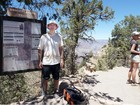
In order to get going at the crack of dawn I went there the day
before to have a look around, take the standard photos, and to check
out the start of the trail
and how to get there from the car parks.
In fact, there is a half-hourly shuttle bus to the start of
the trails from the main Visitor Centre car parking area
(you are not allowed to drive to the starts of the various trails), and
the South Kaibab trailhead is about 10 minutes from the car park.
Here is a map of the car park and Visitor Centre area,
from the above National Park site
(I parked in car park 3, right next to the bus stops;
at 5.15am you can get parked very close to the bus stops!).
• I bought an annual National Parks pass since I was going to several other National Parks and this was well worth it. However, I did find that at 5.10am there wasn't anyone manning the gates, so I didn't need to show it.
•
A useful guide, with good descriptions and fag-packet quality sketch
maps of the trails
(much more useful than detailed topographic maps, which are not
necessary to follow the above trails)
is:
The Grand Canyon, with Bryce and Zion Canyons in America's South
West
by Gibbons, Pritchard-Jones, Roos